Your basket is currently empty
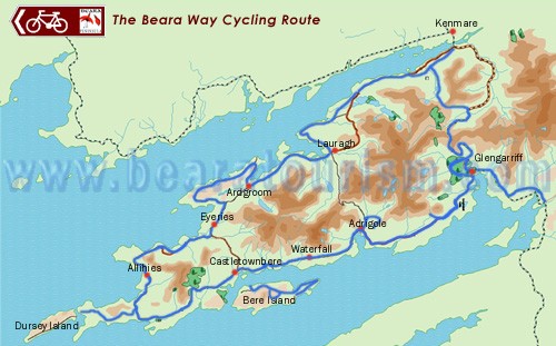
The Beara Way Cycling Route is a National Cycling Route and for most parts is on country roads. The route travels along the entire Beara Peninsula passing through all the towns and villages along the way. The entire route is 183 kms. There is no start or finish so you can join the route in any town and village on the peninsula. The route is sign-posted with a logo and a bicycle symbol.
This route starts inside the Oak Woods just outside Glengarriff Village. It travels through the Oak Woods and joins the main road at Shrone. It travels along the main road over-looking Seal Harbour and Whiddy Island. It then turns up towards Lackavane, passing archeological sites.The lovely village of Glengarriff has for many years been a popular and renowned holiday resort. Glengarriff nestles in a glen in the midst of rocks, cliffs and mountains, at the head of a tiny inlet, in the north-eastern corner of Bantry Bay. Why not take a short boat trip across the bay to Garnish Island, which has a charming Italian garden, Miniature Temple and a Martello tower.
Adrigole is the gateway to the Ring of Beara. The highest Waterfall in Ireland is located on the famous Hungry Hill. The Healy Pass road is a scenic mountain route linking both sides of the Peninsula, so you have the choice of taking the Healy Pass or following the route to Castletownbere along the main road, overlooking Berehaven harbour.
Castletownbere is the Peninsula's principal town. It is the largest whitefish port in Ireland. Berehaven being the second largest natural harbour in the world, it is a safe anchorage for yachts and is also ideal for all water-sports, from sea angling to windsurfing. Just outside the town is Berehaven Golf Club with a magnificent view of Bere Island and Berehaven Harbour. It is a nine hole golf course. Fresh seafood is also served in restaurants all over the Beara Peninsula.
Beside the remains of the older O’Sullivan Bere Castle stands Dunboy Castle, the impressive ruins of a vast 19th Century castle in a bewildering mixture of styles, including French chateaux and Italian villa. The edifice was built by the Puxley family, landlords until 1921, who made their fortune from the copper mines in Allihies. Dunboy woods are open to the public with picnic areas and walks.
In Castletownbere you have the choice of taking 2 ferries: One from Castletownbere - West End, Bere Island and the other from Pontoon (which is located 3 miles Glengarriff side of Castletownbere beside Berehaven Park Golf Course) - Rerrin Village, Bere Island. This is a circular route developed around Bere Island. On Bere Island you can find numerous remains including two intact "6 guns" that are remnants of the British military and naval base that was based there for years. On the south side of the island a French Armada longboat landed in the 1796 invasion of Cuan Baoi, which is now called Bantry Bay. The longboat is now the centrepiece of the Irish Maritime Museum.
The route travels out to Dursey Sound over looking Black Ball Head and finishes at the cable car that is the most western point of the Beara peninsula. At this point you now have the option to take the cable car to Dursey Island and walking part of the Beara Way, or traveling back on your bike and returning the same route for 4 kms where you turn left into Allihies Village which overlooks the famous Ballydonegan Bay.
Allihies was once the site of extensive copper mines and crushed stones from the mines created the Ballydonegan beach.The mountains of Sliabh Miskish surround Allihies on 3 sides and the Atlantic Ocean on the other. The coastline is indented with many inlets. Allihies is also home to many of the famous artists who live on the Beara peninsula.
The route continues along the Coastal route, overlooking Kenmare Bay and Coulagh Bay. Halfway along you arrive at Eyeries Village which overlooks the Atlantic Ocean. It has beautifully painted houses and a flower display on nearly every window.
From Eyeries Village you travel along the coast through Kilcatherine passing many shore angling sites on the way and then arriving into Ardgroom Village. Ardgroom has two lakes, Glenbeg and Derryvegal, both of which provide good trout fishing. Beyond the village there is a perfect example of a Stone Circle, one of the many archeological sites on the Peninsula.The route travels on the back road from Ardgroom Village, passing the Stone Circle and on your right you will see the Caha Mountain range.
You then arrive in Lauragh and have the choice of taking the Healy Pass. Derreen Gardens, beside Kilmackillogue Harbour in Lauragh, were planted 100 years ago by the fifth Lord Lansdowne. The woodland gardens contain many azaleas and rhododendrons. There is also a grove of New Zealand tree ferns.The route continues down past Kilmackillogue Harbour along the road to Tuosist.
You now travel along to Dromoghty Cross and at this junction you can either take the road to Kenmare which links up with the Beara-Kilgarvan Cycling Route and will bring you on to Killarney or turn right to Bunane and take the tunnel road to Glengarriff. Kenmare is a picturesque town with stunning scenery and splendid restaurants.
© 2019-2020 Beara Tourism